River Settings
This document explains how to generate rivers in a level using the MapPreset asset and describes the properties in the River Settings section.
River generation is experimental. It supports only basic flow and shape. Complex water networks, confluences and detailed adjustments have to be made by hand, and the generated result may change in future updates. The property is shown as Generate River (Experimental) in the Details panel.
The river generation process via MapPreset is as follows:
- A random location at a certain height above sea level is chosen as the starting point.
- A Spline is generated that travels down to sea level and is then simplified.
- A WaterBody River actor is created using this Spline.
- The river’s width, depth, and velocity are determined.
- The configured Curve data is normalized.
- The final river width, depth, and velocity are determined by multiplying the normalized Curve data value by the Base Value.
Map Preset River Settings
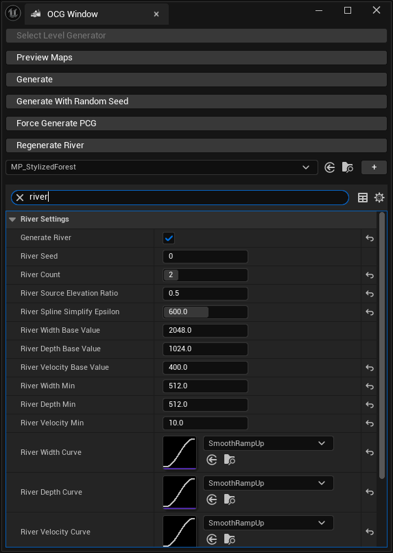
River Generation Parameters
| Property Name | Description |
|---|---|
| Regenerate River | Removes all existing rivers in the current level and generates new ones. Note: This function can only be called in the editor. |
| River Seed | This is the seed for random river generation. Rivers with the same shape will be generated in the same location when using the identical seed. |
| Generate River | Determines whether to generate rivers in the current level. |
| River Count | The number of rivers to generate. A maximum of 10 rivers can be created. |
| River Source Elevation Ratio | A value that determines how high the river’s starting point is from sea level. You can specify a value between 0.5 and 1. The closer to 1, the higher up on the current landscape the river will be generated. |
| River Spline Simplify Epsilon | A value that determines how much to simplify the generated river’s Spline. A higher value results in a more simplified Spline. |
Parameters for River Width, Depth, and Velocity
| Property Name | Description |
|---|---|
| Base Value | The base value for the river’s width, depth, and velocity. It is multiplied by the normalized Curve value to represent the actual river. |
| Curve Data | Determines how the width, depth, and velocity change as the river flows. This is a float curve where the X-axis represents the river’s progress, and the Y-axis represents the width, depth, or velocity value. |
| Minimum Value | The baseline width, depth, and velocity. It is added to the curve-driven value, so the result ranges from Minimum Value to Base Value + Minimum Value, and that total is then scaled by the preset’s Landscape Scale. |
River Materials
All material properties may be left empty. When one is, OCG falls back to the Water plugin’s own default for that slot, taken from Project Settings → Plugins → Water Editor → Water Body River Defaults.
| Property Name | Description |
|---|---|
| River Water Material | The material used to render the river. Applied to the WaterBodyRiver. |
| River Water Static Mesh Material | The material applied to the static mesh used for rendering the river. |
| River To Lake Transition Material | The material used where a river meets a lake. |
| River To Ocean Transition Material | The material used where a river meets the ocean. |
| Water HLODMaterial | The material used for the HLOD representation of the river. |
| Underwater Post Process Material | The material used for underwater post-processing effects inside the river. |
Water HLODMaterial and Underwater Post Process Material also exist under Ocean Settings. Since 2.0.0 the two sets are independent — the river uses the values set here, and the ocean uses its own. In OCG 1.x a single pair was shared by both.