River Settings
This document explains how to generate rivers in a level using the MapPreset asset and describes the properties in the River Settings section.
The river generation process via MapPreset is as follows:
- A random location at a certain height above sea level is chosen as the starting point.
- A Spline is generated that travels down to sea level and is then simplified.
- A WaterBody River actor is created using this Spline.
- The river’s width, depth, and velocity are determined.
- The configured Curve data is normalized.
- The final river width, depth, and velocity are determined by multiplying the normalized Curve data value by the Base Value.
Map Preset River Settings
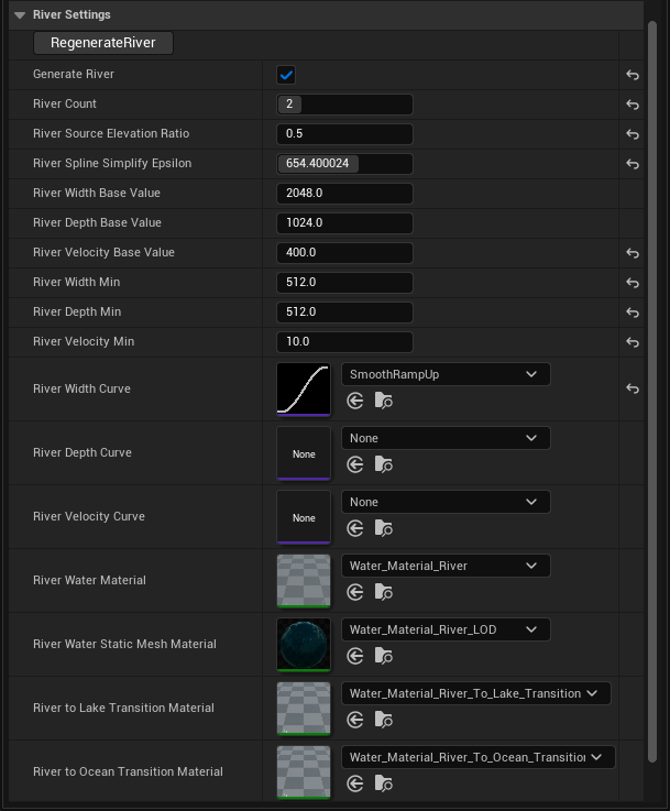
River Generation Parameters
| Property Name | Description |
|---|---|
| Regenerate River | Removes all existing rivers in the current level and generates new ones. Note: This function can only be called in the editor. |
| Generate River | Determines whether to generate rivers in the current level. |
| River Count | The number of rivers to generate. A maximum of 10 rivers can be created. |
| River Source Elevation Ratio | A value that determines how high the river’s starting point is from sea level. You can specify a value between 0.5 and 1. The closer to 1, the higher up on the current landscape the river will be generated. |
| River Spline Simplify Epsilon | A value that determines how much to simplify the generated river’s Spline. A higher value results in a more simplified Spline. |
Parameters for River Width, Depth, and Velocity
| Property Name | Description |
|---|---|
| Base Value | The base value for the river’s width, depth, and velocity. It is multiplied by the normalized Curve value to represent the actual river. |
| Curve Data | Determines how the width, depth, and velocity change as the river flows. This is a float curve where the X-axis represents the river’s progress, and the Y-axis represents the width, depth, or velocity value. |
| Materials | The material properties to be set on the generated Water Body River actor. |